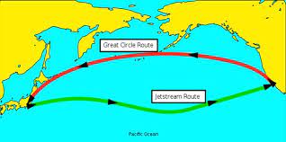
Why Ships follow the curve line?
Just as a car needs a road to travel from one place to another and the car reaches its destination by that road, so a ship needs a road when it crosses the ocean, otherwise the ship will not reach its destination, and will be lost in the ocean. Then the question may naturally come to your mind, where did the road come from again in this great ocean? We will discuss that later, however when we build roads over land we want to keep the distance between source and destination as much as possible along a straight line, to save cost and time. But you've probably noticed something strange in the ship's road map.
For example, the route from Southampton to New York always forces the ship to take a curved path over the sea. Where the biggest issue comes up is extra fuel and increased travel time. We would never like to spend extra fuel and extra time, so obviously ships choose the shortest route possible. So what is the main mechanism of why curved paths are used in these tracks? All this has been discussed in this content.
Actually when you are navigating around the world these curved tracks drawn between source and destination are shorter than a straight line, this is because of the shape of the earth, and the imaginary line across the whole earth is related to latitude and longitude, we all know the shape of the earth is round, more To be specific, it is actually oval, that is slightly flat in the north-south direction, but to understand the matter easily, we do not assume that the earth is round, before going to the main topic, let's understand a few things first. The entire world is surrounded by imaginary lines that help us find the exact location, distance, time zone etc. very easily.
The lines are Latitude or Longitude, Latitude is the horizontal imaginary line, and Longitude is the vertical line. The equator is the main line of latitude, which runs horizontally through the center of the earth. In simple terms, the equator is an imaginary horizontal line of latitude. It divides the northern and southern hemispheres along the middle of the earth. This line has a value of zero degrees, making it a giant force line around the planet. Can be calculated, which is located at an equal distance from the geographic north and south poles.
There are 90 lines of latitude north of the equator and 90 lines of latitude south, each distance equal to 69 miles or 110 kilometers. That is, a line of latitude is imagined for every 1° increase by imagining the equator at 0° at the center of the earth. In this way, by crossing the equator at 0° every 1° upwards, by visualizing a latitude line, the exact location, distance, time zone of any place on earth is determined very easily. And to make this determination more accurate, the earth is divided by 360 imaginary lines of longitude. 0° line of longitude is called Prime Meridian.
Prime Meridian 180 lines west and 180 east. That is, 180 degrees in the west and 180 degrees in the east, a total of 360 degrees. The distance per degree of longitude along the equator is 69.17 miles or 111 kilometers. And as the line of longitude goes towards the pole, the distance decreases. At one point, the longitudes meet and reach zero degrees. Now the question is how to determine the location of an object through latitude and longitude. Well, for example, Bangladesh is located at 23.6 degrees latitude north of the equator and 90.3 degrees east of the Prime Meridian. Now we can easily find the location of Bangladesh. That is, the location of Bangladesh where both the latitude line 23 north of the equator and the longitude line 90 east of the Prime Meridian meet.
GPS systems and satellites determine the position of any object by calculating latitude and longitude. This is why we see that the ships cross the great ocean very easily and never lose their way, but when we look at the great ocean, there is only water and water has no ability to understand anything. However, let's not go that deep, we already understand how many imaginary lines divide the entire earth into latitude and longitude. Now let's get to the point, if you take the two points above the equator, it is very clear that the shortest path would be to travel along the equator.
But as you go north the shortest path starts to curve towards the North Pole and this may not be obvious at this distance, so if we take it further north and get closer to the pole it will obviously be shorter going straight over the pole. Instead of following around parallels in latitude. So it may seem like we are taking a slightly oddly curved path, but in fact we are following the shortest path on the surface of a sphere. In navigation, we call this a greater circle track, which runs between any two points on the surface of the earth. The shortest route between New York and Southampton is this great circle track
. Although it does not appear to be the shortest route at all, when a chart is drawn it is sometimes drawn on a flat surface causing it to appear curved, most viewed chart Among them, the chart is drawn in the Mercator projection method, which is just a method of showing the spherical earth on a flat surface on paper. Where right angles are preserved between equinoctial latitudes and longitudes, we must do so, so that we can easily read the compass bearing from the chart.
Mercator’s projection. The downside is that it extends the Earth's poles, which makes Antarctica seem so large, when in reality it covers a small area at the South Pole. Called the polar projection, the parallels of longitude come together at the poles and the parallels of latitude appear on the curve. The polar projection is very difficult to determine, because the course is very difficult to edit.
Imagine here you are following your compass east then of course the compass will give you 090 degree and variable reading and on the chart your track will follow the curve of parallel latitude east but if we take a greater circle track instead of polar projection then the greater circle track is a straight line would be along the shortest path between two points on the curved surface of a sphere. Since all lines of longitude converge at the poles, the greater circle track crosses each longitude at a different angle, indicating that your compass course will change continuously. Therefore, the method of drawing the greater circle track in Mercator’s projection will be obviously different.
Since Mercator’s projection maps the earth on a flat surface, the lines of longitude cannot converge at a single point. You know that when the ship used to travel along a straight line, each meridian was crossed at a different angle, so the track now looks curved. Actually. This curved track is the straight line track previously drawn on the map of the world. But the track is curved to keep the latitude and longitude lines on a flat surface. So even though this track is curved, it is the shortest route. This explains why ocean paths are drawn as curves. We use spherical trigonometry to manually calculate greater circle track data, we can find the highest point or point east- or west where the ship wants to go, and we can also find the direction that determines our bearing. And we can find the position where we cross each longitude, which effectively gives us a series of straight lines.
In order for us to effectively use a ship's compass on a curved track across the ocean, of course modern navigation technology can accurately plot the curve and an autopilot can steer the ship precisely along that curve, so the next time you cross an ocean you understand you can see that your track doesn't look straight, but you are on a short path that looks like that due to the shape of the earth. I hope you understand why the ship's track looks curved, thanks.

Articles from MASOOD RANA (Entertainment)
View blog
HOW DOES NUCLEAR PLANTS WORK. · A nuclear power plant generates electricity by using the heat produc ...

AK 47 has been one of the most popular and fearsome firearms in the world since 1949. The designer o ...

At various times we see various forces including the army wearing a jacket called a bulletproof jack ...
You may be interested in these jobs
-

Mess Waiter
5 days ago
33 EME Battalion Muzaffarabad, Pakistan Full timeNew 33 EME Battalion Jobs in Muzaffarabad February 2023 have been announced for the below vacant posts through an advertisement published in daily Mashriq Newspaper. A Government Organization invites applications from Pakistani Nationals for appointment to the following posts on ...
-

Non Teaching Staff Jobs
4 days ago
Punjab Daanish Schools and Centers of Excellence Authority Fazilpur, Pakistan Full timeNon Teaching Staff Jobs in Fazilpur December 2023 has been Announce through their Official Website.Punjab Daanish Schools and Centers of Excellence Authority, Government of the Punjab offers opportunities to highly dynamic and committ professionals in Non Academic Staff.In these ...
-
Accounting Supervisor
6 days ago
Smart Accounting & Tax Services Lahore, Pakistan Full timeWe are seeking a highly skilled and motivated Accounting Supervisor to join our team. The ideal candidate should have completed their CA articles from a reputable firm, with a specific focus on Audit/Accounting. The candidate should possess knowledge and hands-on experience in ac ...
Comments